Report
to/Rapport au :
and Council / et au Conseil
13 June 2011 / le 13 juin 2011
Submitted by/Soumis
par : Nancy Schepers, Deputy City
Manager
Directrice municipale
adjointe, Infrastructure Services and Community Sustainability
Services d'infrastructure et Viabilité des collectivités
Contact Person/Personne-ressource : Richard Kilstrom,
Manager/Gestionnaire, Policy Development and Urban Design Branch/Élaboration des
Politiques et Design urbain, Planning and Growth Management/Urbanisme et
Gestion de la croissance
(613) 580-2424, 22653 Richard.Kilstrom@ottawa.ca
REPORT
RECOMMENDATIONS
That Planning Committee
recommend Council:
1.
Approve the Old Ottawa East Community Design
Plan (distributed separately and on file with the City Clerk and shown as
Document 5);
2. Approve an amendment to the Official
Plan, Schedule B, to change the Traditional Mainstreet designation for Main
Street south of Clegg Street to General Urban Area, to designate Hawthorne
Avenue between Colonel By and Main Street as Traditional Mainstreet, and to
change the designation of various lands to Mixed Use Centre or Major Open
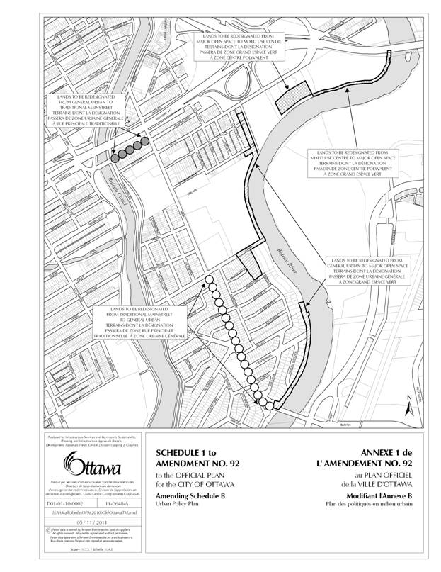
Space, all of which is shown in Document 2 and detailed in Document 6;
3.
Approve an amendment to the Official Plan to add
to Volume 2A the Old Ottawa East Secondary Plan as detailed in Document 6
(distributed separately and on file with the City Clerk); and
4.
Approve an amendment to Zoning By-law 2008-250
to change the zoning of properties marked as Areas A to R on Document 3, all of
which is detailed in Document 4.
RECOMMANDATIONS DU RAPPORT
Que le Comité de l'urbanisme recommande au
Conseil :
1.
d'approuver le plan de conception communautaire pour le Vieil Ottawa-Est
(distribué séparément et conservé dans les dossiers du greffier municipal,
étant le document 5);
2.
d'approuver une modification du Plan officiel, annexe B, afin de faire
passer le zonage de la rue Main située au sud de la rue Clegg de « rue
principale traditionnelle » à « zone urbaine générale »,
d’attribuer la désignation « rue principale traditionnelle » à
l'avenue Hawthorne entre la promenade Colonel-By et la rue Main et d’attribuer
à divers terrains la désignation « centre polyvalent » ou
« grande aire ouverte », comme l’illustre le document 2 et le précise
le document 6;
3.
d'approuver une modification du Plan officiel afin d'ajouter au volume
2A le Plan secondaire du Vieil Ottawa-Est, comme le précise le document 6
(distribué séparément et conservé dans les dossiers du greffier municipal); et
4. d'approuver
une modification du Règlement de zonage 2008-250 afin de changer le zonage des
propriétés constituant la zone A à R dans le document 3, comme le précise le
document 4.
EXECUTIVE SUMMARY
Assumptions and Analysis
This report
recommends approval of the Old Ottawa East Community Design Plan (CDP), the Old
Ottawa East Secondary Plan covering the same area as the CDP, and related
Zoning By-law amendments, which contribute to the implementation of these
plans.
The planning strategy
of the CDP and Secondary Plan provide a framework for change that will see Old Ottawa
East as it is today become the community of tomorrow. A unifying vision foresees an attractive and
livable urban community, based on “green” principles and featuring a wide mix
of uses, enhanced green spaces, excellent transit service and well-designed
development that will build the area’s diversity and vibrancy. Compatible intensification will occur
primarily on appropriate sites along the Traditional Mainstreets, including
Main Street, Hawthorne Avenue, and the Mixed Use Centre along Lees Avenue
adjacent to the Lees Transit Station, where Official Plan policy objectives
related to compatible development can be met.
The CDP area
currently contains about 5100 dwelling units.
A minimum intensification target for the area projected to 2030 would add
1500 new dwellings, which represents a moderate increase from the existing
zoning development potential.
The CDP also projects
that the current mix of residential and commercial uses on the Mainstreets will
continue; that some of the existing institutional uses will be replaced by
residential/commercial mixed use; and that the Lees Avenue Mixed Use Centre
will continue to provide an opportunity for increased office employment use in
association with the development of the University of Ottawa campus and the
Lees Transit Station.
The CDP proposes a
detailed building envelope and infill development guidelines derived from a
broad-based assessment of the Old Ottawa East area to help achieve the Official
Plan’s compatibility principles for intensification in established
neighbourhoods. More specific guidance
is provided in particular for the properties currently owned by the Oblate
Fathers, the Sisters of the Sacred Heart, and St. Paul University, which have
considerable redevelopment potential and where a change in ownership and use is
expected in the near term.
A greenspace network
strategy is also proposed, including improved pathway links to the Rideau River
and Canal, enhancement of Ballantyne Park and Legget Park as civic spaces, and
the greenway corridor along the Rideau River with its string of recreation
facilities, natural features and scenic river frontage.
The CDP planning
exercise made use of the findings of the Main Street Traffic and Streetscape
Study (Delcan, 2000) to determine the potential changes to the road system and
streetscape environment. A number of
improvements have been carried out in the past decade and there remains the
potential for more depending on traffic volumes and road reconstruction.
The financial
implications of the Old Ottawa East CDP and Secondary Plan are that it contains
several proposals for capital improvements to streets, parks and City
facilities throughout the area. When
these initiatives come forward in future work programs, they will have budget
implications that will be addressed at that time.
A summary of the
public consultation program, including the comments received, is detailed in
Document 7.
Financial Implications:
Capital improvement project proposals listed in the implementation section of the Community Design Plan, and in the Appendix of the Secondary Plan, that require City funding, will be brought forward through the City’s capital budget and will be subject to Council approval.
If any of the amendments adopted through this report were to be appealed to the OMB and the City is required to retain an outside firm, then a precise estimate of the cost will be provided by the City Clerk and Solicitor Department at the time.
Public Consultation/Input:
Notice of the subject amendments was carried out in conformity with the City's Public Notification and Consultation Policy. Outstanding issues related to the subject amendments include the permitted height of buildings within the Traditional Mainstreet, intensification targets, and the Alta Vista Transportation Corridor.
RÉSUMÉ
Hypothèses et analyse
Le présent rapport
recommande l’approbation du Plan de conception communautaire (PCC) pour le Vieil
Ottawa-Est, du Plan secondaire pour le Vieil Ottawa-Est, qui porte sur le même
secteur que le PCC, ainsi que des modifications de zonage connexes, qui
concourent à la mise en œuvre de ces plans.
La stratégie
d’urbanisme contenue dans le PCC et le Plan secondaire prévoient un cadre de
changement en vertu duquel le Vieil Ottawa-Est d’aujourd’hui deviendra la
communauté de demain. Une vision
unificatrice prévoit une communauté urbaine attrayante, où il fait bon vivre,
basée sur des principales écologiques et comportant des utilisations variées,
de meilleurs espaces verts, un excellent service de transport en commun et un
développement bien conçu, qui assurera la diversité et le dynamisme du
secteur. Il y aura une densification
compatible, qui s’effectuera principalement sur des sites appropriés, le long
des rues principales traditionnelles, notamment la rue Main, l’avenue Hawthorne
et le centre polyvalent situé le long de l’avenue Lees, dans le voisinage de la
station de transport en commun Lees, où il est possible d’atteindre les
objectifs du Plan officiel en matière d’aménagement compatible.
Le secteur visé par
le PCC compte environ 5 100 logements à l’heure actuelle. L’objectif de densification minimum fixé pour
2030 devrait donner lieu à l’ajout de 1 500 logements, ce qui constitue
une augmentation modérée, par rapport au potentiel de développement inhérent au
zonage actuel.
Le PCC prévoit aussi
que la combinaison actuelle d’utilisations résidentielles et commerciales le
long des rues principales sera maintenue; que certaines des utilisations
institutionnelles seront remplacées par une utilisation résidentielle et
commerciale; et que le centre polyvalent de l’avenue Lees continuera d’offrir
la possibilité d’accroître le nombre d’emplois de bureau, parallèlement au
développement du campus de l’Université d’Ottawa et de la station de transport
en commun Lees.
Le PCC propose des
lignes directrices détaillées pour ce qui concerne l’enveloppe des bâtiments et
les aménagements intercalaires. Ces lignes directrices découlent d’une
évaluation générale du Vieil Ottawa-Est qui avait pour but de contribuer à
l’application des principes de compatibilité énoncés dans le Plan officiel pour
ce qui est de la densification des quartiers établis. Le PCC énonce aussi certaines orientations
plus précises, notamment en ce qui concerne les propriétés qui appartiennent
aux Pères Oblats, aux Sœurs du Sacré-Cœur et à l’Université St‑Paul. Ces
propriétés comportent un potentiel de réaménagement considérable et l’on
s’attend à ce qu’elles fassent l’objet d’un changement de propriétaire et
d’utilisation à court terme.
Le Plan prévoit
également une stratégie d’établissement d’un réseau d’espaces verts, et
notamment l’amélioration des sentiers de raccordement à la rivière et au canal
Rideau ainsi que la mise en valeur des parcs Ballantyne et Legget comme lieux
publics et du couloir de verdure le long de la rivière Rideau, qui comporte une
série d’installations récréatives, de caractéristiques naturelles et de grèves
panoramiques.
Les auteurs du PCC se
sont appuyés sur les conclusions de l’étude sur la circulation et le paysage de
rue sur la rue Main (Delcan, 2000) pour déterminer les modifications possibles
au réseau routier et au paysage de rue.
La dernière décennie a donné lieu à un certain nombre d’améliorations et
d’autres peuvent être apportées, en fonction de la densité du trafic et de la
réfection des routes.
Les répercussions
financières du PCC et du Plan secondaire pour le Vieil Ottawa-Est tiennent au
fait qu’il propose plusieurs améliorations aux immobilisations dans les rues,
les parcs et les installations municipales du secteur. Lorsque ces initiatives seront mises en œuvre
dans le cadre de programmes de travaux futurs, elles auront des répercussions
budgétaires dont il faudra alors tenir compte.
Le document 7
renferme un résumé du programme de consultation publique, y compris des
commentaires qui ont été reçus.
Répercussions financières
Les propositions de projets
d'amélioration des immobilisations énumérées dans la section « Mise en
œuvre » du Plan de conception communautaire, ainsi que dans l’annexe du
Plan secondaire, et qui requièrent un financement de la Ville, seront examinées
dans le cadre du budget des immobilisations de la Ville et seront sujettes à
l’approbation du Conseil.
Si l’une ou l’autre des recommandations
adoptées par le biais du présent rapport devait faire l’objet d’un appel à la
CAMO et que la Ville doive retenir les services d’une firme extérieure, alors une
estimation précise des coûts sera fournie par le Bureau du greffier municipal
et chef du contentieux à ce moment-là.
Consultation publique/commentaires :
Les modificatons en cause ont donné lieu à la publication
d'avis conformément à la politique sur les consultations et les avis publics.
Les questions qui demeurent en suspens relativement aux modifications en cause
concernent la hauteur permise des immeubles sur les rues principales
traditionnelles, les objectifs de densification et le couloir de transport
d'Alta Vista.
BACKGROUND
In the fall of 2005, the Old Ottawa East Community Association (OOECA) responded to development occurring on Main Street by organizing workshops to create a vision for the future of the community.
A survey was also conducted to gain input from the community. This helped to expand on the key themes that emerged in the workshops by generating a list of desired land uses. With the support of then Councillor Clive Doucet’s office, a request for staff and resources was brought forward to Committee and Council to initiate a Community Design Plan process that would test and formalize the community vision created in the workshop setting.
A Public Advisory Committee (PAC) was formed with representatives from the OOECA, institutional and business stakeholders in the community. A “terms of reference” was drafted in consultation with the PAC, and the CDP proceeded through a process that spanned three years, including three public open house meetings where several drafts of the CDP were presented and discussed with the community. The City website has been used to track the planning process and provide updates on the CDP as it progressed. Comments from the open houses were also posted on the site with links to reference material and related planning documents.
The goal of the process is to prepare a CDP focused on Main Street but also responsive to the vision of the Old Ottawa East community as a whole. The plan is meant to provide a broad and integrated 20-year vision and guidance for the growth of the area.
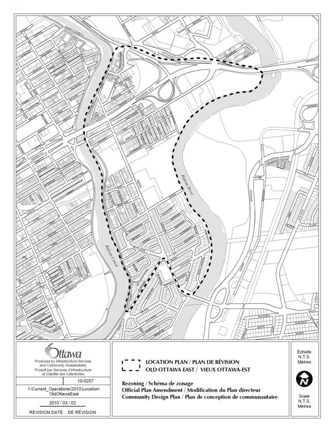
The CDP boundaries as shown on the Location Map, (Document 1) generally include Colonel By Drive on the north, the Rideau Canal on the west, the Rideau River on the east, the McIlright Bridge and Riverdale Avenue on the south. Main Street is the existing Traditional Mainstreet that bisects the community north to south. The CDP encompasses a number of smaller neighbourhoods that are influenced by their proximity to Main Street, including Archville, Spenceville, and Rideau Gardens. The large size and varied character of the planning area necessitated that it be divided into a number of precincts along the length of the Main Street corridor and its adjoining neighbourhoods.
This CDP was prepared for presentation to Planning
Committee last June but the institutional property owners (Oblate Fathers,
Sisters of the Sacred Heart, and St. Paul University) requested a deferral to
allow a more detailed process to consider options for the development of their
land. As this was considered to be an
important parcel (12 hectares) within the community and the owners had not
previously engaged in the CDP process, it was decided to defer the approval
until a Demonstration Plan could be produced to illustrate and inform further
detailed policy direction and zoning for this land. The process over the past year has involved
staff working with consultants for these owners and the community to develop a
Demonstration Plan. A number of
workshops and related meetings were held over the past year, which culminated
in a public open house on March 10th at St. Paul University. The Plan was generally well received by the
community with a few issues being raised with respect to vehicle access to
Clegg Street, provision for community gardens within the plan, the desire for
indoor programmable community space, and the height and density proposed. The community representatives on the Public
Advisory Committee generally support the Demonstration Plan and do not consider
these issues to be a barrier to its approval.
The Demonstration Plan is attached as Appendix 1 to the CDP and the
Powerpoint presentation of this plan is available for viewing on the Ottawa
East Community Association website.
DISCUSSION
RECOMMENDATION 1
Recommendation 1 is to approve the CDP as Council’s direction for the future development of the Old Ottawa East area. The Plan projects a broad and integrated 20-year guiding vision for the growth of the area.
It provides a survey of existing conditions, policies to direct future change within the various precincts and neighbourhoods of the community, and an implementation strategy, including zoning, built heritage, transportation and streetscape improvements, capital projects, and design guidelines. As such the CDP provides a framework to manage and assess changes to land use and built form within the community to the year 2031.
Planning Strategy
The CDP’s planning strategy will provide direction for change that will see the community as it is today evolve into the vision for the future. This unifying vision foresees an attractive and liveable urban community, based on sustainable planning principles and featuring a wide mix of uses, improved green spaces, excellent transit, cycling and pedestrian connections and well-designed development that will enhance the area’s diversity and vibrancy. Compatible intensification will occur on appropriate Traditional Mainstreet sites along and contiguous with Main Street and Hawthorne Avenue, and within the Lees Avenue Mixed Use Centre adjacent to the Lees Transit Station, as directed by the Official Plan. Urban Design policies will direct that the valued existing characteristics of the community are retained and enhanced. It will also ensure that new development of the public and private realm will contribute to a compact, mixed-use, walkable and sustainable built form. Parks and open spaces will be improved in order to fulfill their role to serve for recreation, leisure, natural environment and civic design functions. Heritage resources will be identified, conserved and integrated with new development. Pathways and routes through the community will provide improved access. Infrastructure will be upgraded over time to ensure that the growth anticipated by the land use designations and zoning can be accommodated.
As the CDP process was undertaken concurrent with the creation of a new Comprehensive Zoning By-law for the city, there was an opportunity to influence the zoning for the study area as the plan was being formed. Some major aspects of the Comprehensive Zoning By-law, such as the building envelope for the Traditional Mainstreet (TM) zone, were based on experience gained with examples from Main Street in Old Ottawa East. Therefore, when the new Zoning By-law 2008-250 was adopted in May of 2008 it included much of the zoning that is appropriate to implement the policies of this CDP. There remain a few zoning amendments for the Traditional Mainstreet corridor and more extensive changes for the lands currently owned by the Oblate Fathers, Sisters of the Sacred Heart and St. Paul University that are referred to in Recommendation 4 to bring the zoning into conformity with the general intent of the CDP and the more specific proposals of the Demonstration Plan that is attached as Appendix 1 to the CDP.
While there are currently no heritage districts and only three designated properties within the community there are a number of properties that are on the Heritage Reference List. Among the properties identified as having heritage interest are a number of schools and monastic buildings that have considerable potential for adaptive reuse in any redevelopment. Therefore the CDP suggests that an architectural conservation study be undertaken with respect to any proposal for redevelopment of a property that is included on the Heritage Reference List. This will ensure that all options for heritage conservation are explored early in the Site Plan process.
The CDP projects that a minimum of 1500 new residential units could be built in the community out to the time horizon of 2031. This is a moderate expectation relative to the 2500 dwelling units representing full build-out of the properties designated as Traditional Mainstreet.
Much of the potential increase in units is focused on the Traditional Mainstreet corridor along Main Street and Hawthorne Avenue as well as the Mixed Use Centre at the east end of Lees Avenue and the Lees Transit Station. Contiguous to Main Street are the institutional lands currently owned by the Oblate Fathers, Sisters of the Sacred Heart and St. Paul University that provide a large portion (minimum 1000 dwelling units) of the potential for intensification in Old Ottawa East.
Housing affordability is addressed in the CDP by reinforcing the policy direction of the Official Plan. Essentially the goal to provide 25 per cent of new housing within the affordable range will be applied within the area of Old Ottawa East. This will ensure that a proportional allotment of affordable housing is provided within the community.
Capital improvement projects are listed and described in the CDP in order to identify the public realm improvements that will be undertaken as part of any street reconstruction, park development or other City facilities. The improvements have been strategically identified to support the land use and urban design strategy of the CDP. They will be built over the life cycle of this Plan.
Design guidelines are provided in the CDP to assist with the development review process with respect to projects that will be presented over the life of the plan. Projects may be either private sector developments or public realm improvements by the City or other public agency. The guidelines are intended to be applied with discretion and with due consideration for the context of the project.
RECOMMENDATION 2
Recommendation 2 is to amend Schedule B to the Official Plan to eliminate the Traditional Mainstreet designation for Main Street south of Clegg Street. The Traditional Mainstreet designation was applied by City Council to the full length of Main Street as part of Official Plan Amendment 28 in 2005. The intent was to ensure that the Mainstreet develop as a compact, mixed-use, pedestrian-orientated form of development. However, the analysis carried out as part of this CDP reveals that the area south of Clegg Street is a stable, low-rise residential neighbourhood, which is not considered suitable for a Mainstreet built form. Therefore, it is recommended that the length of Main Street south of Clegg Street be designated General Urban Area consistent with the remainder of the residential neighbourhoods in Old Ottawa East.
Also as part of the analysis undertaken as part of this CDP, it was noted that the length of Hawthorne Avenue between Colonel By Drive and Main Street is in transition to a mix of residential, retail and service-type uses. It forms a direct connection with the Glebe neighbourhood to the west via the Pretoria Bridge and is part of the Highway 417 collector road network. It provides an important route for all modes of transportation through the community. Therefore, it is considered suitable for a Traditional Mainstreet designation. The built form will accommodate to the lot configurations that are existing along the street.
Modifications to the Major Open Space designation are proposed along the west bank of the Rideau River to update the configuration of this designation with respect to development that has occurred on private property, parks that exist along this corridor, and to provide the land needed to support a Multi-use Pathway in conformity with Schedule I of the Official Plan.
RECOMMENDATION 3
The adoption of a Secondary Plan, which provides an extract from the CDP, is considered important to establish the legal status of the key policy direction for Old Ottawa East. The Secondary Plan essentially divides the CDP into three parts including Part A, The Preamble, that introduces the actual Amendment but does not constitute part of the amendment; Part B, The Amendment, constitutes the actual amendment to the Official Plan; and Part C, The Appendix, does not form part of the amendment but is provided to describe how the Amendment would be implemented.
RECOMMENDATION 4
As the Comprehensive Zoning By-law was under review during the CDP process, a number of adjustments were made to the zoning of the community as part of that review. The CDP process informed the larger zoning review throughout the community. However, there are zoning amendments that are proposed to address details of the CDP as follows:
- Within the TM7 zone now existing along Main Street, it is proposed that parking garages not be permitted within the ground floor of a building. This is intended to support the policy direction to provide for continuous retail use along the street frontage of buildings on the Traditional Mainstreet.
- A number of amendments are proposed to implement the form of development illustrated in the Demonstration Plan (Appendix 1 to CDP). The TM7 zone extends along the frontage of the property on Main Street. Low-rise residential zones are proposed abutting the neighbourhood to the north along Springhurst. A mixed-use General Commercial zone is located within the interior of the site and mid-rise residential zoning is located abutting the open space along the Rideau River. An O1 zone extends along the river frontage to encompass the required 30-metre setback to any buildings. A dual R5/O1 zone defines an area of potential park or mid-rise residential development depending on the final configuration of parkland dedication that is determined at the time of development. The entire area of the Demonstration Plan is subject to a holding zone that will be lifted conditional on the approval of a Site Plan Control application for the property.
Summary
The above-noted discussion provides the rationale for the recommendations of this report. The CDP, Secondary Plan, Official Plan Amendment and related Zoning By-law Amendments create a comprehensive framework for evaluating new private development and set standards for improvements to the public realm within Old Ottawa East. This is considered to be an appropriate framework for the 20-year life of the Plan, dependent on adjustments that may take place as part of five-year reviews of the Official Plan.
RURAL
IMPLICATIONS
N/A
CONSULTATION
Notice of this new CDP, Secondary Plan, related Official Plan and Zoning By-law amendments was carried out in accordance with the City's Public Notification and Consultation Policy.
The outstanding issues can be summarized as follows:
- The six-storey height limit along the length of the area designated Traditional Mainstreet is opposed by the Old Ottawa East Community Association (OOECA). They would prefer that building heights be restricted to four storeys south of Immaculata High School on the west side of Main Street.
- The OOECA would prefer that the intensification targets outlined in the CDP be generalized for the entire community rather than focused on the Traditional Mainstreet.
- The OOECA would like the CDP to state that the Alta Vista Transportation Corridor would negatively impact the community.
- A group of residents from Brantwood Park to the south of St. Paul University have requested that the Demonstration Plan not show a road access to Clegg Street from the Oblate property. They are concerned about traffic impacts on their neighbourhood.
- Residents with allotment gardens on the Oblate lands want to maintain a location for these within or adjacent to the development that is illustrated in the Demonstration Plan.
- The height and density of development illustrated on the Demonstration Plan is opposed by some in the community.
Detailed responses to the proposed CDP, Secondary Plan, Official Plan and Zoning By-law amendments are provided in Document 7.
COMMENTS BY THE WARD
COUNCILLOR
“The CDP is a very promising document and a reflection of the hard work and commitment of all parties involved, including the property owners, the community, and City staff. As the CDP is implemented in the years ahead, all parties must remain cognizant of the additional demand for public amenities that will accompany the steady growth associated with the CDP. In that regard, additional schools, daycare, indoor community spaces, playgrounds and other community services will be in demand. More and more families with young children are returning to the urban core, as they trade long drives and large yards for walkable commutes and shared City parks. This growing trend will need be to be taken into account by all parties as the CDP moves from the drawing board to reality.
I am aware that some residents of Clegg Street and Marlowe Crescent do not want to allow vehicle access to the pending re-development from Clegg. However, I am inclined to agree with City planners who maintain that it is important to include access to the re-developed lands from more than one street. My sense is that developments that are not integrated into the larger surrounding community have a higher likelihood of failure. In addition, an important objective must be to integrate in some fashion the old and new, so that residents of the new development will feel included in the older community, and that the existing community will feel comfortable coming and going through this new precinct. I have seen where restricted road and travel access has created a “gated community” feeling, and it is not a positive thing.
“A balance, however, must be
achieved whereby some additional flow and integration is provided but not to
the point where existing, quieter residential streets become fundamentally
altered or overwhelmed by a large volume of new traffic.”
LEGAL IMPLICATIONS
As a City initiated matter, in the event that Council were to determine not to adopt the Official Plan Amendments and/or Zoning By-law recommended in this report, no appeal rights would exist. In the event that the Official Plan Amendments and/or Zoning By-law are adopted substantially in the form in which they have been recommended to Council and should they be appealed to the Ontario Municipal Board, it is anticipated that the hearing could be conducted within staff resources. The length of the hearing would depend upon the number and nature of the appeals to the amendments. Should a modification be made to the amendments that Planning staff advise that they cannot provide professional opinion evidence to support, it would be necessary to retain an outside firm if an appeal of that provision were made to the Board. An estimate of the costs that would be incurred by the City could be provided if the precise details of such a modification were introduced.
RISK MANAGEMENT IMPLICATIONS
There are no risk management implications with this report.
FINANCIAL IMPLICATIONS
Capital improvement project proposals listed in the implementation section of the Community Design Plan, and in the Appendix of the Secondary Plan, that require City funding, will be brought forward through the City’s capital budget and will be subject to Council approval.
If any of the amendments adopted through this report were to be appealed to the OMB and the City is required to retain an outside firm, then a precise estimate of the cost will be provided by the City Clerk and Solicitor Department at the time.
ENVIRONMENTAL IMPLICATIONS
Approval of the Community Design Plan will ensure that open space is protected along the Rideau River and runoff does not negatively impact on the quality and quantity of this waterway. The intensification of development within this community will provide for a compact, mixed-use and walkable built form. Large parcels of land will be developed with a LEED standard for environmental sustainability. New bicycle and walking paths will be secured through the community thus providing an alternative to reliance on motorized vehicles. New development will bring a new landscape with many new trees and shrubs and general greening of the area.
TECHNOLOGY IMPLICATIONS
N/A
CITY STRATEGIC PLAN
The Plan for Old Ottawa East addresses many objectives of the Strategic Plan. In particular it excels at the following:
- It provides a Sustainable, Healthy and Active City by outlining a policy direction for a (Objective 6) walkable, transit and cycling-oriented community and employment centre.
- It is exemplary in Planning and Growth Management by (Objective 1) becoming leading edge in community and urban design; ensuring that new growth is integrated seamlessly with established communities; ensuring that community facilities are built in tandem with new development; and (Objective 3) ensuring that the City infrastructure required for new growth is built or improved as needed to serve growth.
SUPPORTING DOCUMENTATION
Document 1 Location Map
Document 2 Proposed Official Plan Amendment Map
Document 3 Proposed Zoning Amendment Map
Document 4 Details of Recommended Zoning
Document 5 Old Ottawa East Community Design Plan (distributed separately and on file with the City Clerk)
Document 6 Old Ottawa East Secondary Plan (distributed separately and on file with the City Clerk)
Document 7 Consultation Details
DISPOSITION
Planning and Growth Management Department to undertake the follow-up implementation measures outlined in the CDP and Secondary Plan.
Notify the Parks, Recreation and Cultural Services Department and the Infrastructure Services Department of Council’s decision regarding the CDP recommendations with respect to capital projects.
Planning and Growth Management to prepare the by-law adopting the Official Plan Amendment and Zoning
By-law amendments, and forward to Legal Services.
Legal Services will forward the implementing by-laws to City Council.
Notify persons who made oral or written submissions at the Planning and Environment Committee meeting, as well as all persons who requested to be notified of the adoption of the Official Plan amendment and Zoning By-law amendment.
LOCATION MAP DOCUMENT 1
PROPOSED OFFICIAL PLAN AMENDMENT MAP DOCUMENT 2
PROPOSED ZONING AMENDMENT MAP DOCUMENT 3
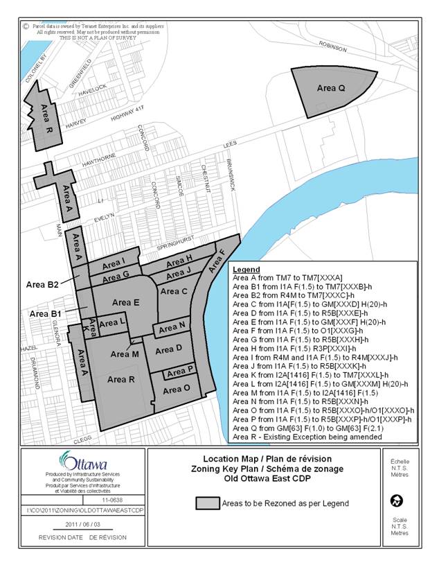
DETAILS OF RECOMMENDED ZONING DOCUMENT 4
Details of Recommended Zoning:
1. Rezone the subject properties shown on Document 3 as follows:
(a) Area A is rezoned from TM7 to TM7[XXXA]
(b) Area B1 is rezoned from I1A F(1.5) to TM7[XXXB]-h
(c) Area B2 is rezoned from R4M to TM7[XXXC]-h
(d) Area C is rezoned from I1A[F(1.5) to GM[XXXD] H(20)-h
(e) Area D is rezoned from I1A F(1.5) to R5B[XXXE]-h
(f) Area E is rezoned from I1A F(1.5) to GM[XXXF] H(20)-h
(g) Area F is rezoned from I1A F(1.5) to O1[XXXG]-h
(h) Area G is rezoned from I1A F(1.5) to R5B[XXXH]-h
(i) Area H is rezoned from I1A F(1.5) R3P[XXXI]-h
(j) Area I is rezoned from R4M and I1A F(1.5) to R4M[XXXJ]-h
(k) Area J is rezoned from I1A F(1.5) to R5B[XXXK]-h
(l) Area K is rezoned from I2A[1416] F(1.5) to TM7[XXXL]-h
(m) Area L is rezoned from I2A[1416] F(1.5) to GM[XXXM] H(20)-h
(n) Area M is rezoned from I1A F(1.5) to I2A[1416] F(1.5)
(o) Area N is rezoned from I1A F(1.5) to R5B[XXXN]-h
(p) Area O is rezoned from I1A F(1.5) to R5B[XXXO]-h/O1[XXXO]-h
(q) Area P is rezoned from I1A F(1.5) to R5B[XXXP]-h/O1[XXXP]-h
(r) Area Q is rezoned from GM[63] F(1.0) to GM[63] F(2.1)
2. Add the following exceptions to Section 239 containing provisions similar in effect to those listed within the following Table: